Log in
All resources
Create a design
1,000 Free Images of Joan Blaeu
copper engraving print
british library
maps by willem and johannes blaeu
atlas maior, vol 2 (sweden, russia, poland, eastern europe, and greece) - joan blaeu, 1667 - bl 114.h(star).2
1667 maps
novus atlas sinensis
maps with figures
maps with cartouches
atlas maior, vol 1 (northern europe, norway, and denmark) - joan blaeu, 1667 - bl 114.h(star).1
bibliothèque nationale de france
atlas maior, vol 3 (germany) - joan blaeu, 1667 - bl 114.h(star).3
old maps of upper austria
atlas maior, vol 2 (sweden, russia, poland, eastern europe, and greece) - joan blaeu, 1667 - bl 114.h(star).2
copper engraving print
atlas maior, vol 1 (northern europe, norway, and denmark) - joan blaeu, 1667 - bl 114.h(star).1
1667 maps
historical images of the moscow kremlin
17th-century maps of moscow
atlas maior, vol 2 (sweden, russia, poland, eastern europe, and greece) - joan blaeu, 1667 - bl 114.h(star).2
17th-century maps of poland
atlas maior, vol 1 (northern europe, norway, and denmark) - joan blaeu, 1667 - bl 114.h(star).1
1667 maps
atlas maior, vol 7 (france i) - joan blaeu, 1667 - bl 114.h(star).7
1667 maps
atlas maior, vol 4 (netherlands) - joan blaeu, 1667 - bl 114.h(star).4
1667 maps
atlas maior, vol 8 (france ii and switzerland) - joan blaeu, 1667 - bl 114.h(star).8
1667 maps
atlas maior
1672 books
maps by willem and johannes blaeu
fort-mardyck
armillary spheres in art
novus atlas sinensis
riga in the 17th century
old maps of riga
books burned in 1944 (national library in warsaw)
books
atlas maior, vol 1 (northern europe, norway, and denmark) - joan blaeu, 1667 - bl 114.h(star).1
1667 maps
atlas maior, vol 3 (germany) - joan blaeu, 1667 - bl 114.h(star).3
copper engraving print
atlas maior, vol 8 (france ii and switzerland) - joan blaeu, 1667 - bl 114.h(star).8
1667 maps
atlas maior, vol 3 (germany) - joan blaeu, 1667 - bl 114.h(star).3
copper engraving print
atlas maior, vol 3 (germany) - joan blaeu, 1667 - bl 114.h(star).3
nova & accurata ducatuum slesvici et holsatiae tabula
atlas maior, vol 2 (sweden, russia, poland, eastern europe, and greece) - joan blaeu, 1667 - bl 114.h(star).2
1667 maps of russia
atlas van der hagen (volume 4)
atlas van der hagen
atlas maior, vol 2 (sweden, russia, poland, eastern europe, and greece) - joan blaeu, 1667 - bl 114.h(star).2
maps of slavonia by gerardus mercator
atlas maior, vol 2 (sweden, russia, poland, eastern europe, and greece) - joan blaeu, 1667 - bl 114.h(star).2
1667 maps of russia
atlas maior, vol 1 (northern europe, norway, and denmark) - joan blaeu, 1667 - bl 114.h(star).1
1667 maps
novus atlas sinensis
maps of zhenjiang
atlas maior, vol 2 (sweden, russia, poland, eastern europe, and greece) - joan blaeu, 1667 - bl 114.h(star).2
copper engraving print
atlas maior, vol 2 (sweden, russia, poland, eastern europe, and greece) - joan blaeu, 1667 - bl 114.h(star).2
1667 maps of russia
old maps of ukraine
atlas novus (blaeu)
maps of rotterdam by berckenrode
kolk (rotterdam)
eran laor cartographic collection
joan blaeu
atlas maior, vol 2 (sweden, russia, poland, eastern europe, and greece) - joan blaeu, 1667 - bl 114.h(star).2
coats of arms of the tsardom of russia
maps by willem and johannes blaeu
maps of rotterdam by berckenrode
old maps of latvia
maps of livonia
atlas maior, vol 2 (sweden, russia, poland, eastern europe, and greece) - joan blaeu, 1667 - bl 114.h(star).2
17th-century maps of the aegean sea
atlas maior, vol 3 (germany) - joan blaeu, 1667 - bl 114.h(star).3
17th-century maps of silesia
atlas maior, vol 4 (netherlands) - joan blaeu, 1667 - bl 114.h(star).4
1667 maps
atlas maior, vol 2 (sweden, russia, poland, eastern europe, and greece) - joan blaeu, 1667 - bl 114.h(star).2
copper engraving print
atlas maior, vol 1 (northern europe, norway, and denmark) - joan blaeu, 1667 - bl 114.h(star).1
1667 maps
old maps of the county of ravensberg
atlas novus (blaeu)
eran laor cartographic collection
joan blaeu
eran laor cartographic collection
joan blaeu
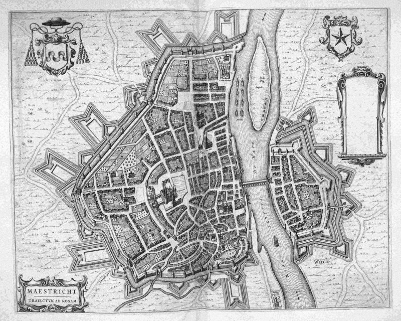
map of maastricht by willem and johannes blaeu (1649)
statenkwartier (maastricht)
atlas maior, vol 2 (sweden, russia, poland, eastern europe, and greece) - joan blaeu, 1667 - bl 114.h(star).2
17th-century maps of scandinavia
atlas maior, vol 2 (sweden, russia, poland, eastern europe, and greece) - joan blaeu, 1667 - bl 114.h(star).2
1667 maps of russia
atlas maior, vol 2 (sweden, russia, poland, eastern europe, and greece) - joan blaeu, 1667 - bl 114.h(star).2
copper engraving print
atlas maior, vol 1 (northern europe, norway, and denmark) - joan blaeu, 1667 - bl 114.h(star).1
1667 maps
maps by willem and johannes blaeu
novus atlas blaeu
novus atlas sinensis
lotus in art
atlas maior, vol 4 (netherlands) - joan blaeu, 1667 - bl 114.h(star).4
1667 maps
archipelagus orientalis
atlas maior, vol 1 (northern europe, norway, and denmark) - joan blaeu, 1667 - bl 114.h(star).1
1667 maps
atlas maior, vol 1 (northern europe, norway, and denmark) - joan blaeu, 1667 - bl 114.h(star).1
1667 maps
maps with cartouches
old maps of fujian
maps by willem and johannes blaeu
old maps of jan mayen
novus atlas sinensis
old maps of shanxi
atlas maior, vol 2 (sweden, russia, poland, eastern europe, and greece) - joan blaeu, 1667 - bl 114.h(star).2
copper engraving print
atlas maior, vol 2 (sweden, russia, poland, eastern europe, and greece) - joan blaeu, 1667 - bl 114.h(star).2
copper engraving print
atlas maior, vol 3 (germany) - joan blaeu, 1667 - bl 114.h(star).3
copper engraving print
map of maastricht by willem and johannes blaeu (1649)
atlas beudeker
atlas maior, vol 2 (sweden, russia, poland, eastern europe, and greece) - joan blaeu, 1667 - bl 114.h(star).2
copper engraving print
17th-century maps of herefordshire
1646 maps
atlas van der hagen (volume 4)
people with animals in art
maps by willem and johannes blaeu
17th-century maps of europe
novus atlas sinensis
old maps of jiangxi
17th-century maps of herefordshire
old county maps of herefordshire
maps by willem and johannes blaeu
maps of szolnok
nuevo atlas o teatro mundo
old maps of the arctic
map of maastricht by willem and johannes blaeu (1649)
jekerkwartier (maastricht)
novus atlas sinensis
old maps of sichuan
maps by willem and johannes blaeu
old maps of vlaardingen
novus atlas sinensis
old maps of guangxi
maps of liège by johannes blaeu - derivative files
maps in the library of congress
novus atlas sinensis
cartouches by willem and johannes blaeu
maps made in the 17th century
old maps of enkhuizen
atlas van loon
maps by willem and johannes blaeu
1651 in germany
maps by willem and johannes blaeu
1662 maps of norway
maps in the library of congress
old maps of yunnan
maps by willem and johannes blaeu
collections of limburgs museum
old maps of the holy land
joan blaeu
old maps of the holy land
joan blaeu
maps by willem and johannes blaeu
stjärneborg
maps in the library of congress
novus atlas sinensis
coats of arms of grand duchy of lithuania
magni ducatus lithuaniae
maps by willem and johannes blaeu
maps made in the 17th century
old maps of new france
1663 maps
maps by willem and johannes blaeu
new amsterdam
1645 maps of belgium
tournaisis
map of maastricht by willem and johannes blaeu (1649)
nieuwstad fortifications (maastricht)
praefectura paranambucae pars borealis, una cum praefectura de itâmaracâ
georg marggraf
1660s maps of pernambuco
1660s maps of brazil
maps of luxembourg city walls
old maps of luxembourg city
maps by willem and johannes blaeu
maps made in the 17th century
atlas van der hagen (volume 4)
atlas van der hagen
media from atlas of mutual heritage on dutch east india company
portolan charts by willem and johannes blaeu
old maps of duchy of troppau
maps of duchy of jagerndorf
coats of arms of grand duchy of lithuania
magni ducatus lithuaniae
maps by willem and johannes blaeu
old maps of henan
maps with figures
maps by willem and johannes blaeu
701 - 800 of 1,000
Next page
/ 10


![Kaarte vande Buyck-slooter… Meeren; [b] Caerte Van De Purmer; [c] Byllemer-Meer, Joan Blaeu, 1667](https://cdn.creazilla.com/illustrations/10000501445/kaarte-vande-buyck-slooter-meeren-b-caerte-van-de-purmer-c-byllemer-meer-joan-blaeu-1667-md.jpg)


![Titelblad] AFRICA](https://cdn.creazilla.com/illustrations/10000408184/titelblad-africa-sm.webp)


